Earthquakes – a serious hazard for Switzerland
After ten years of intensive research, the Swiss Seismological Service (SED) at ETH Zurich has created an updated seismic hazard model, which confirms that earthquakes are a serious hazard for Switzerland.
Every year, the SED registers more than 500 earthquakes in Switzerland. The most recent moderate earthquake occurred three years ago: an earthquake with a magnitude of 4.2 originated 30 kilometers below the earth’s surface in the vicinity of Zug. It was clearly felt by tens of thousands of people across central and eastern Switzerland. This example demonstrates that moderate earthquakes occur repeatedly in Switzerland. But a strong or even catastrophic earthquake could also occur at anytime, anywhere in Switzerland. Predicting the potential strength of earthquakes and how often they could occur at specific locations is a key area of research for the Swiss Seismological Service.
Different regional hazard levels
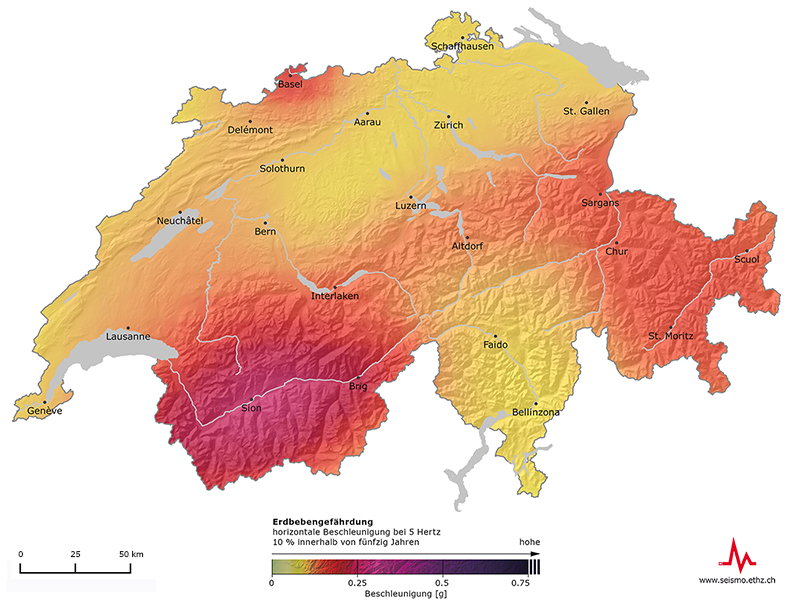
Estimates suggest that in Switzerland earthquakes are the natural hazard with the greatest potential for causing damage. On behalf of the federal government, the SED monitors earthquake activity and estimates the level of seismic hazard in Switzerland. The SED regularly publishes a model describing possible future earthquakes and the associated ground movements. The newly-published, updated seismic hazard model is based on improved predictive models, new and more exact data, and revised estimates based on historical sources. It replaces the model from 2004 and facilitates a more concrete assessment of the level of hazard. Experts and authorities will use the new model as a basis for making decisions regarding earthquake mitigation and the risk management involved.
Overall, estimates of the hazard level in individual regions have changed only slightly since 2004. Valais remains the area with the highest level of hazard, followed by Basel, Graubünden, the St. Gallen Rhine Valley, and central Switzerland. According to the SED’s estimates, only the canton of Graubünden, and in particular the Engadine, has a higher level of hazard than previously assumed. This slightly higher hazard can be explained by a revised understanding of previous earthquakes in the region.
Different maps, different factors
Alongside the classic hazard map, which uses acceleration values to depict where and how often earthquakes of a particular strength are to be expected, the SED has launched two additional products this year. These provide the population with better access to the relevant information. One of the two new maps illustrates the effects that earthquakes of different sizes entail. The other map shows how often earthquakes of a particular magnitude occur. All products can be accessed through an interactive Web tool.
Another striking addition is the new color concept for the hazard map: the “harmless” greens and blues that dominated the 2004 map have been replaced with shades of yellow, orange, red and purple. This new color scheme is a much better reflection of the actual seismic hazard in Switzerland: in principle, a strong earthquake is possible in any region of Switzerland at any time.
Establishing protective measures
An important factor in the calculation of seismic hazard is the expected ground acceleration. In recent years, researchers have collected volumes of new data from the vicinity of major earthquakes, both in Switzerland and abroad. Subsequent evaluations have shown that the ground shifts considerably more during certain earthquakes than previously assumed. On the basis of these findings, the SED has adjusted the estimates of likely ground movements. These values are especially significant for construction engineers, who must take them into account when designing earthquake-resistant buildings and infrastructure.
The hazard map is an important instrument not only for engineers, but also for authorities, insurance companies, and researchers. These interested parties use it primarily as a basis for making decisions regarding earthquake mitigation and risk management. Furthermore, the standards for earthquake-resistant building design are also based on the hazard map.
The Swiss Seismological Service at ETH Zurich
The Swiss Seismological Service (SED) at ETH Zurich is the official federal agency for earthquake monitoring. The SED monitors earthquake activity in Switzerland and its neighboring countries and assesses Switzerland’s seismic hazard. When an earthquake happens, the Swiss Seismological Service informs the public, the authorities, and the media about the earthquake’s location, magnitude, and possible consequences. Further information can be found at: www.seismo.ethz.ch/index_EN